ORIGINS OF THE PARK’S TRAILS AND SHAPE
Why does the park have such a complex shape?
The 482-acre park was originally part of a 1-mile square (640-acre) tract of land (Section 16) donated to the state by the federal government at statehood in 1889, for the purpose of supporting public schools. Bridle Trails was set aside as a state park in in the early 1930s, in response to a petition by local horseback riders to the Commissioner of Public Lands. State Parks eventually purchased the land for the park system, but not before most of it was logged and some of it was sold, in both cases to create revenue for schools.

Land was sold in two 80-acre tracts in 1904 and 1908, as indicated by the two whitish notches in the Department of Natural Resources Tract Page for Section 16 to the left.
The notch on the north end of the park now contains the Bridlewood Circle, Kirkland Hunt Club, and Flying Horseshoe neighborhoods, as well as the Central Park Tennis Club on NE 60th St. The notch in the southwest section now contains the Sablewood, Bridgewood Estates, and Corsun neighborhoods.
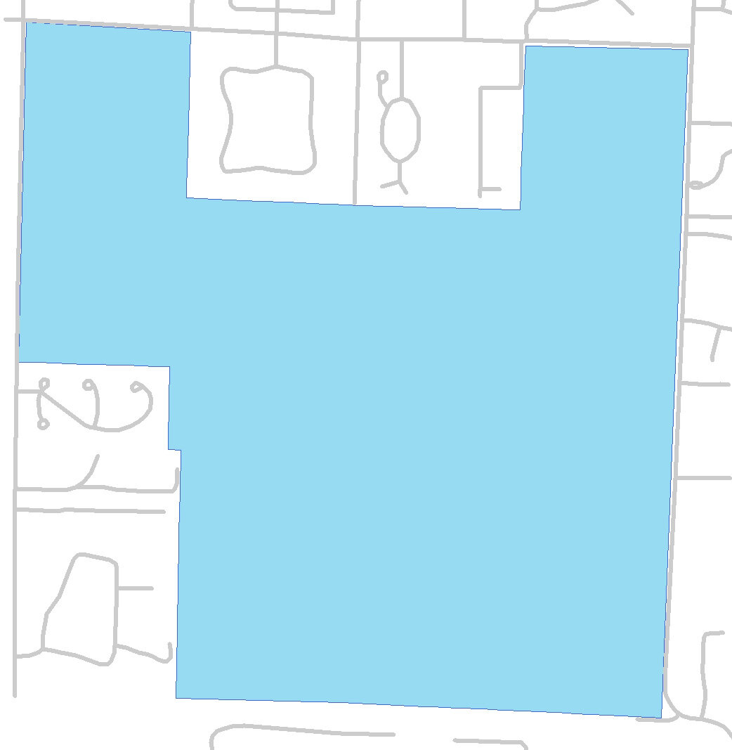
A narrow, nearly 2-acre strip of land was added on the west side of the southwest section in 1967, transferred by the City of Bellevue as mitigation for an easement on land used for a water storage tank at the south end of the park.
(Another roughly 5 acres was added in 2006, when Lois Acheson deeded land east of 132nd Ave NE at NE 52nd St to State Parks.)
How was the trail system in the park created?
Much of the current 28-mile trail system in the park was already present in 1936, the last year that logging occurred and the earliest for which there exist aerial photos. The trails were used for accessing logging sites and removing the timber, and by horseback riders for recreation. Early loggers probably used horses to “skid” (drag) the logs from where felled to a landing, where the logs were loaded onto wagons to move them out of the park. It is very likely that at least some of the main trails were adequate for wagons. An overlay of a 1936 aerial photo and the current trail system shows that many of the whitish trails seen in the photo align pretty closely with many of the current trails. The photo also shows how much of the Section 16 had been recently logged.
Was there ever a road through the park?
An early history of Kirkland (Our Foundering Fathers) and local historian (Tom Hitzroth) indicate that there was a road (wagon track) through Section 16, possibly in use as early as the 1880s and until the early 1920s. The road was between the Redmond area and Curtis Landing on Lake Washington, which was owned by of one of the first families to settle Kirkland. Curtis Road shows up (unnamed) on a series of Kroll maps from the early 1900s.

Kroll maps from 1912 (left) and 1922 (right)
The maps show Section 16 labeled as “School,” given the purpose of the land at the time to make revenue for public schools. Curtis Road entered the west side of the park at what is now the main entrance on 116th Ave NE at NE 53rd St. It is last shown on a 1922 map, and is shown stopping inside Section 16 in a 1926 map. By 1936, after Section 16 had become a park, the road was no longer shown on maps of the park. So, what is that other road in the park showing on the 1922 map above, heading southeast from what is now the main trail head? We don’t know. Another mystery.
How did Curtis Road get up that steep hill?
The 1936 aerial photo does not show the current parking lot near the park entrance and indicates that the big hill one now needs to climb to get into the park from the lot was not present, either. It is likely that the parking lot was subsequently carved out of the slope, and Curtis Road did not have to go up the steep hill we have to huff up today. The parking lot was still not present in a 1960 aerial photo, was about 1/3 built in a 1965 photo, and was completed by 1972. You can see in the map below the overly steepened hill above the flat areas of the showgrounds and parking lot, where the topographic lines (2-foot contours) are close together.
